Ice and Water
Circular Thinking on Cultural and Environmental Sustainability
Maps
The history of the Arctic has been documented in maps. The ways in which the Arctic has been mapped, represented and visualised is often revealing of the ways in which the region has been 'constructed', interpreted and ultimately 'owned'.
Compare the three maps in this gallery. What do they reveal?
1. Claudius Ptolomaeus, Cosmographia (Ulm: Holle,1482), Courtesy of Special Collections, University of Aberdeen.
2. Olaus Magnus, Carta Marina (Rome, 1539) (WikiCommons)
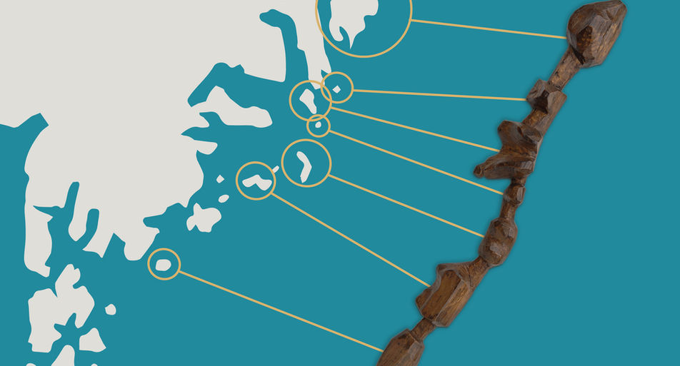
3. Inuit Carved Map (1880s) Photo courtesy of Greenland National Museum and Archives, Illustration by Mark Garrison
Ptolomaeus's Cosmographia written around AD150 remained very influential - and kept being reproduced - until the early-modern period. Placing the mythical 'Thule' next to Shetland and charting the North as 'Hiperborium', the Atlas reflects the sense of 'mystery' attached to the world's northernmost region, which is surrounded by an ominously named 'Mare Congelatum' (Frozen Sea').
Swedish Cartographer Olaus Magnus's depiction fills the Northern region with all sorts of supernatural and extraordinary kinds, from sea serpents to water pigs. Carta Marina, first published in 1539, was followed by Olaus's A Description of the Northern Peoples (1555), a companion to the wonders of Europe's northernmost region. These works challenge the idea of the North and the Arctic as barren, empty spaces.
Used by Danish explorer Gustav Holm in the 1880s, the Inuit map, carved in wood and designed to be held in the palm of one's hand, tells a different story. Rather than attempting to compress a large and diverse region, both the design and the medium speak of the indigenous emphasis on local knowledge and closeness to the geography of the Arctic.
Re-mapping the Arctic and the Far North
One of the planned outputs of Ice and Water will be an accessible map that puts the Arctic and Far North - and their indigenous people and stories - in the centre.
A way to share some of the knowledge behind 'Ice and Water' and new findings from our research project.
You can preview the interactive map by clicking on the static image below. We will be constantly updating this, so keep coming back to see what's new!


